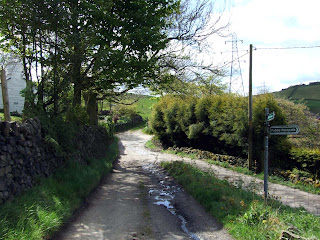
The outer edges of the Peak District have a lot to offer if you're after a nice relaxing walk with some nice wide views. This walk, situated at the far end of Woodhead Pass , not far from the A628 route to Manchester from Barnsley is around 7 miles in length. It has some nice scenic views, and some views right across Manchester
On your left, looking out, Manchester City Centre is clearly visible.
The path continues north for about half a kilometre and then starts to turn right with Walkerwood Reservoir coming into view after another hundred meters or so.
The path heads down the incline to thread it's way between Walkerwood Reservoir and Brushes Reservoir. You climb up the opposite side of the valley and find the point where the Pennine Bridleway crosses the head of this path. Turning right takes you directly east along the Pennine Bridleway which winds slowly right and then left along the northern bank of Brushes Reservoir up to Lower and Higher Swineshaw Reservoirs.
The path turns east again across the head of Upper Swineshaw Reservoir with a great view south to Lower Swineshaw Reservoir and the surrounding countryside.
While we had a stop at Upper Swineshaw Reservoir we found that we had found the flight path directly into Manchester Airport, and it was a busy day. Some very large airliners landed that day.
From Upper Swineshaw Reservoir we headed east and around the back of Lees Hill. We then headed right (South, a slight diversion off the Pennine Bridleway) past the Disused Quarry, over Middle Bank and down towards Devil's Bridge.
Here we took a right turn through the Swallows Wood Nature Reserve and joined back up with the Tameside Trail. This is a worthwhile diversion as the Nature Reserve is worth a look.
After the Reserve, the Pennine Bridleway heads south, for around one kilometre, around Meadowbank Farm (take your wellingtons).
The path then and comes out into a housing estate. Turn right and follow the road for around 200 meters and you will find a Public Footpath off to the right. The path heads easterly around the north side of the school grounds with Thorncliffe Hall on your right to the north. The path here is quite rocky, but pleasant as it has a nice setting.
The path continues east past Lumb Farm and onto Dewsnap Lane. At the end of the lane, turn left, approximately 100 meters down the road you come back to the lay-by.
Having a good look on the map, this walk has a lot of scope for alternative routes and longer or shorter versions. I hope this gives you an idea for a nice walk in this area.
The walk started from a small lay-by on Hobson Moor Road
between Mottram and Stalyhill. Around 50 meters back from the lay-by is the Public Footpath heading roughly NNW with Shaw Moor up on your right.


No comments:
Post a Comment