Situated to the north east of Kettlewell on the east side of Wharfedale in the Yorkshire Dales, Great Whernside stands a whole two meters higher than Buckden Pike. While I was in the Dales last year I went to check Great Whernside out, but was put off by low clouds. Wanting to see the views from up there I delayed my return visit until we had some good weather. And boy did I drop on the first week in June.
You head out of Kettlewell up the extremely steep Cam Gill Road. The road takes a ninety degree turn to the right some hundred meters up the road with the path continuing straight on up the road.
The path through Cam Pasture up to Cam Head gains some height quite rapidly, opening up some beautiful views.
When you near the top of the path, off to the right Great Whernside comes clearly into view.
Off ahead you pick up Starbottom Road where the path leads onto what appears to be a really nice ridge following. The path for the ridge passes through Tor Dike above Diamond Hill.
Looking south, Kettlewell has pretty much disappeared out of site. The valley is clearly visible with the River Wharfe cutting it's way through.
At this point the path meets back up with Cam Gill Road. The path cuts straight across and is clearly sign posted once on the other side.
Looking across at Great Whernside, the path of ascent can just be made out. It can be seen to cross a wall about two thirds of the way up. I have marked a red line to show roughly the route I followed. I wouldn't depend on this exactly as the route at the bottom is pock marked with sub-surface streams making the going very boggy. However, once above this lower lying boggy area a path becomes quite clear.
As you make your way Great Whernside, having passed Black Dike Hole, some new views appear, including Buckden Pike, and the Three Peaks.
The path crosses the stile that could be seen from the bottom, crossing a wall.
Once across the stile the path becomes a nice stead stroll with a slight incline. The path goes past Little Crags, leading up to Blackfell (699m). At this point there is a small stone shelter (marked as Pile of Stones on map) where I stopped for a bit of a break. Off to the south I could see the Great Whernside cairn.
On my way to the Great Whernside summit cairn I looked back to take a photograph of Blackfell, the shelter and Little Crag behind.
The cairn at the summit is quite pile. There are some very good sheltered areas in a northerly direction from the cairn along the ridge if there is a need. It was very windy when I was up there and some shelter can be appreciated when taking a break.
From the south side of the summit cairn I picked up the path which heads back down into Kettlwell.
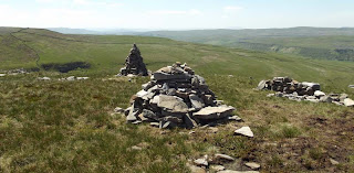
Some way down you come to a ridge with a very high cairn. This looks to be made to such a height to make the route clear to anyone ascending.
Looking down you can clearly see the Hag Dyke youth hostel run by the YHA. At this point you need to be careful as the path passes down through a very rocky area where some of the rocks are quite loose. It would be easy to take a tumble here, so watching your footing and making sure any rocks you step on are stable.
The path leads around behind the building and on towards Hooksbank.
The path leads back down past Hoobank Pasture and back into the picturesque village of Kettlewell.
A superb area to walk in, Kettlewell would make a good starting point for many walks. Well worth a visit, I certainly will be going back.


No comments:
Post a Comment